
The rain came through during rush hour, and at the same time, it created some spectacular images. NBC 7’s Dave Summers talked to drivers about how they navigated this summer storm.
Severe thunderstorm and flash flood warnings were issued by the National Weather Service Thursday afternoon for parts of eastern San Diego County.
The storm moved northwest, prompting a severe thunderstorm warning for central San Diego County.
Another severe thunderstorm warning was issued for southeastern San Diego County near northern Boulevard and Live Oak Springs.
Parts of south-central San Diego County were under a flash flood warning until 9 p.m. due to heavy rain from thunderstorms impacting the area, including Alpine, Potrero, Lake Morena, Campo, Tecate and Dulzura.
Get top local stories in San Diego delivered to you every morning. Sign up for NBC San Diego's News Headlines newsletter.
"Some locations that will experience flash flooding include... I-8 Between Boulevard And Imperial County Line, Hwy S2 Between Canebrake and Imperial County Line, Hwy S2 Vallecito Creek Rd, Hwy S2 Between Agua Caliente And Canebrake, Fish Creek Wash, northern Boulevard, Canebrake, Manzanita Indian Reservation and Campo Indian Reservation," read the warning issued around 6 p.m.
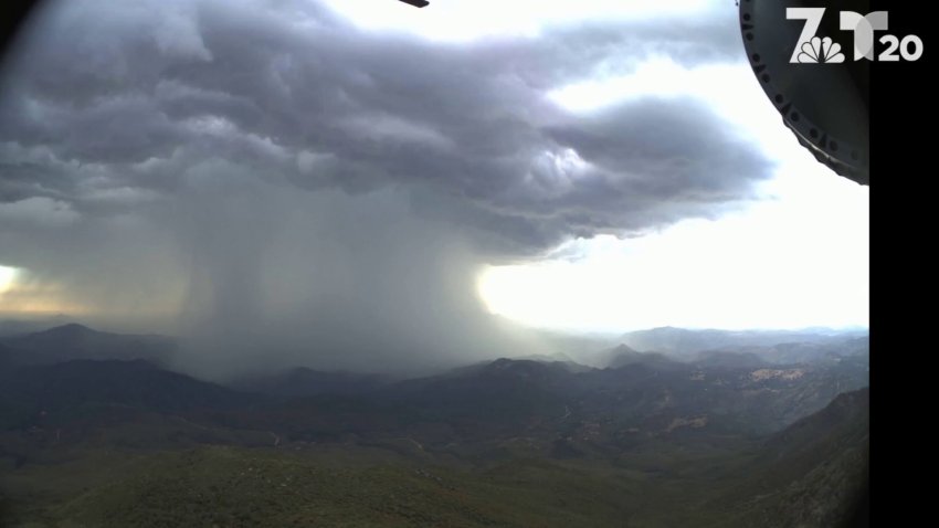
Thunderstorms first popped up near the border and Potrero area, NBC 7 meteorologist Greg Bledsoe said, adding that there were also reports of lightning and a small brush fire. The cells then moved through the county to the northwest, reaching coastal North County by 7 p.m.
Local


The camera from Cuyamaca Peak captured a breathtaking timelapse video of a thunderstorm rolling through San Diego County. The storm brought heavy rain, gusty winds and lightning in some areas.
"I almost felt like I was in Hawaii. The humidity and rain — it was kind of cool. It was nice for a change," Ramona driver Michael Austin said. "Rain during the summer, you don't usually see that."
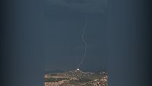
There were 1,350 lightning strikes, with 142 of those being cloud to ground, according to Bledsoe. One ground strike lightning was photographed in Santee by viewer Randy Siegel.
Some streets were saturated, while others dried up quickly because of the heat.
Dangerously hot temperatures were in the forecast Thursday in parts of San Diego County with an excessive heat watch in effect in the desert communities.
The NWS issued the heat watch from Saturday morning until Sunday in Banning and the San Gorgonio Pass, where high temperatures are expected between 110-115 and lows between 87-90.
The heat watch is also in effect in Cathedral City, out near Palm Springs, and Borrego Springs where highs are expected between 113-117 and lows between 85-90.
There was a slight chance of thunderstorms and morning fog in the forecast in the valleys, where highs were expected between 82-86 Thursday. Thunderstorms were predicted in the mountains with highs from 87-96.
The NWS recommends drinking plenty of fluids, staying in an air-conditioned room and out of the sun, and checking up on relatives and neighbors.
