San Diego weather today: Brooke Martell’s forecast for March 12, 2025.
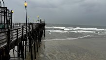
San Diego County was bracing for even more rainfall as one storm moved out of the region Wednesday to make way for an even more powerful system.
The first storm system already brought up to an inch of rain by Wednesday morning. Some areas could still see some light, scattered showers on Wednesday, while other areas stay completely dry. The respite would be short-lived, though, because another storm was ready to move in overnight Thursday with rain and snow and strong winds.
“We’re not done with that rain just yet, NBC 7 Meteorologist Brooke Martell said. Wednesday's rain "is the remnants of the system we had yesterday… We’re kind of in between storms because we have a more significant system moving through early [Thursday] morning.”
Get top local stories in San Diego delivered to you every morning. Sign up for NBC San Diego's News Headlines newsletter.
The first storm touched down overnight Tuesday, but the main band of rain moved through in the afternoon — delivering a healthy dose of rain. Rain totals were approaching an inch in some places, including San Diego's airport, which has seen its single rainiest day in nearly a year.
"This first round is lighter rain and a warmer system," NBC 7 meteorologist Greg Bledsoe said. "Any snow we get out of this round would come overnight into Wednesday morning and only at San Diego's highest peaks."
Local


"By Thursday afternoon and into the overnight, we could see the snow level drop down as low as 3,000 feet. Higher peaks like Mount Laguna and Palomar Mountain could see more than 6 inches of snow," Bledsoe said.
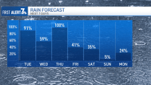
In all, from Tuesday through Saturday, San Diego could see between an inch and two inches of rain, NBC 7 meteorologist Brooke Martell said.
Tracking the storm
Tuesday and Wednesday
The first showers began falling early Tuesday from Oceanside to Imperial Beach and east into the valleys. The rain tapered off a bit between 9 to 11 a.m. before the second round moved in, staying through the evening commute, Martell said.
Areas west of the mountains could experience rain accumulations of 0.50’’-0.70’’, while the mountains could see up to an inch by the time the first storm moves through.

Thursday and Friday
The second storm will be colder and a lot heavier, Martell said. This is when we could expect snow in our mountains. Snow levels could drop down as low as 3,000 feet by late Thursday into Friday morning. Martell said areas as low as Julian, Pine Valley and even stretches of Interstate 8 could see snow.
There are chances for light showers again on Friday and possibly into early Saturday morning as well. Most of the weekend looks dry and slightly warmer.

Watches and advisories in San Diego County
A flood watch will be in effect for San Diego County's coasts, valleys and mountains from Wednesday evening through Thursday afternoon.
A wind advisory will be in effect for the deserts from Wednesday night through Friday morning.
The NWS also issued a winter weather watch from Thursday morning until Friday morning for the county's mountains.