
Tropical Storm Hilary updates as of 11 p.m. Sunday
- Hilary was downgraded to a tropical storm, but the storm was still expected to bring between 2 and 10 inches of rain, winds from 15-70 mph, flash floods and possible mudslides as it moved across San Diego County
- The center of Hilary was located about 105 miles northwest of San Diego as of 9:30 p.m. on Sunday
- The Red Cross opened overnight shelters in San Marcos and Chula Vista
- Closures and cancellations
- Damages and power outages
- Rain map
- How to prepare for Hilary
- Where to get free sandbags
- Hilary pushes Navy ships to leave San Diego bases
What started as the Category 4 Hurricane Hilary late last week was downgraded to a tropical storm by Sunday morning — hours before its center started moving across San Diego County and other parts of Southern California.
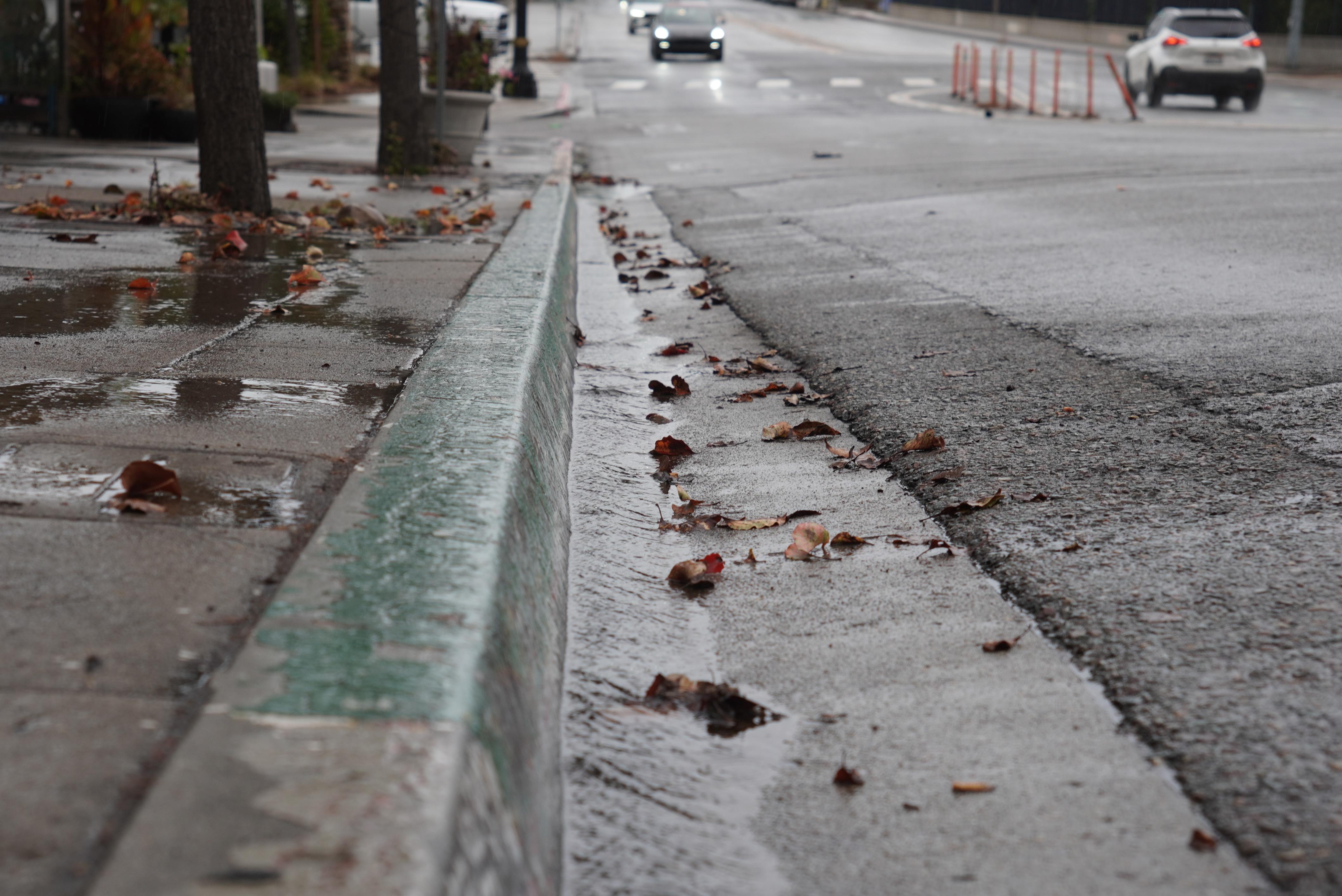
Winds were reaching up to 84 miles per hour in parts of the county on Sunday, and some communities saw more than 6 inches of rainfall, leaving behind swamped roads and downed trees.
Get top local stories in San Diego delivered to you every morning. Sign up for NBC San Diego's News Headlines newsletter.
The center of Hilary was located about 105 miles northwest of San Diego as of 9:30 p.m. on Sunday. It was picking up speed and tracking north, on its way to places like Nevada and Idaho.
NBC 7 Meteorologist Francella Perez says the bands of heavy rain will continue into Sunday night and that winds will pick up in North County and coastal areas.
"It's still a strong tropical storm with winds sustained, 50 miles per hour. It's moving quickly to the north, 23 miles per hour, and it's getting closer and closer to Palm Springs," Perez said during the 6 p.m. newscast.
The National Weather Service issued a flood watch that will be in effect through Monday afternoon in San Diego County.
Heavy rains were affecting portions of western Mexico, the northern Baja California Peninsula and the Southwestern U.S.
A flash flood warning was issued for Jacumba, Boulevard, Mount Laguna until 2:30 p.m. and for Descanso and Borrego Springs until 4 p.m., according to the National Weather Service of San Diego.
In San Diego County, light rains leftover from Saturday night progressed into the morning. The eye of the storm was projected to hit the county between 3 p.m. and 6 p.m. Sunday.
Hilary was weakening as it neared San Diego County, but was still expected to remain a tropical storm by landfall and bring a potentially historic amount of rainfall -- causing life-threatening to locally catastrophic flash, urban and arroyo flooding, including landslides, mudslides and debris flow into Monday morning.
San Diego County residents living in high terrain can expect the strongest winds, such as short gusts of wind from 60-75 mph. Sustained winds are moving at 25-35 mph. Those at the coasts and valleys can expect wind gusts of 15-25 mph, according to NBC 7 meteorologist Brooke Martell.
Hilary will bring up life-threatening surf and rip currents, affecting parts of the Baja California Peninsula and SoCal into Monday and possibly Tuesday.
Some areas in the mountain and deserts could see over 2 inches of rain per hour during the peak storm period and 10-12 inches in total, while the coastal region was expected to get up to 2 inches total.
Authorities are advising people to avoid driving during the storm if at all possible and many closures and cancellations have already been announced.
The Red Cross opened overnight storm shelters in San Marcos and Chula Vista for people who were forced from their homes. The shelters have food and will accommodate for pets, children, seniors and those with disabilities.
- Corky Smith Gymnasium: 274 Pico Avenue, San Marcos, CA 92069
- Southwestern College Jaguar Aquatics Wellness and Sports: 900 Otay Lakes Road, Chula Vista, CA 91910
County and agency leaders hold press conference on Sunday ahead of storm's landfall
From the National Weather Service to the San Diego County Board of Supervisors, county and agency leaders gathered Sunday afternoon ahead of tropical storm Hilary’s arrival midafternoon. The officials gave updates on the county’s latest conditions and what residents should do to stay safe.
The storm has already gathered strength and moisture before making landfall from 2 to 6 p.m. in San Diego County, said Alex Tardy, NWS Warning Coordination Meteorologist.
“This is a historic event,” Tardy said. The mountains and desert areas will receive a large amount of rain, which is highly unusual for August, he said.
Different parts of the county will be hit differently, with rural communities to be affected the most. Coastal communities will receive winds from the north during the peak of the storm.
Anywhere in the county, winds of 40 mph could blow through with short wind gusts of up to 60 mph, Tardy said.
Saturday, Aug. 19
San Diego Mayor Todd Gloria and local leaders gave an update on storm preparations for Hurricane Hilary on Saturday afternoon. This comes after a first-ever tropical storm warning was issued for Southern California as Hilary threatened to deliver rain, flash flooding and strong winds to the San Diego County area this weekend in a historic severe weather event.
At the press conference at U.S. Coast Guard San Diego, Gloria advised community members to avoid driving in flood zone areas, ensure gutters and storm drains are clear from debris and charge essential devices.
The city's Storm Patrol crews will respond to temporary flooding and downed trees and branches.
As for the unsheltered population, Gloria said there are an additional 192 shelter beds available at four locations and that 146 people from the Safe Sleeping site at 20th and B have been temporarily relocated to Golden Hall.
He also said the city is acquiring more sandbags to make sure needs are met.
“I want to say rest assured that our city crews and first responders are ready to respond to the impacts and emergencies that will come, and we appreciate you doing your part to make sure we can all stay safe together," he said.
The mayor wanted to remind residents they can get information at sandiego.gov/storm.
And in the event of a power outage, go to sdge.com/outages for status updates and to see the full service map.
Gov. Gavin Newsom declared a state of emergency around 6 p.m. Saturday for much of Southern California ahead of Hurricane Hilary's projected landfall. He was in San Diego visiting the emergency operations center, according to Gloria.
On Saturday afternoon, the governor activated the State Operations Center at the Governor’s Office of Emergency Services (Cal OES), focusing on positioning emergency resources, maintaining road safety, protecting vulnerable communities, coordinating with private sector retailers like Target, and closing state parks and beaches.
“He assured me that the state of California is watching and monitoring the storm closely and that the full weight of our state government will be here to support our city before, during and after this event,” Gloria said.
Following Newsom's steps, San Diego County officials proclaimed a local emergency in response to Hilary on Saturday around 9:30 p.m. The proclamation allows county officials to use "all available resources, actions and measures deemed necessary" to protect residents.
The California Governor's Office of Emergency Service (Cal OES) held a press conference Saturday afternoon with officials from the NWS, the state's Department of Water Resources, California Highway Patrol, FEMA and more.
"This storm will also bring the potential for isolated tornadoes across portions of Southern California. In addition, we’re expecting life-threatening surf and rip current conditions along the beaches of Southern California. The worst impacts are expected on the east side of the inland mountains and into the desert southwest," said Courtney Carpenter from the NWS.
"Make no mistake this is a very very dangerous and significant storm," said Cal OES Director Nancy Ward.
"There will be power outages, make no mistake. There will be power outages across Southern California," Ward added.
"If you do not need to be on the roadways we are asking you to postpone any of your nonessential travel until the peak of the storm passes," said Caltrans Director Tony Tavares.
"FEMA, in this stage we’re going to emphasize on preparedness. You've heard it and yet you're not able to hear it enough and that is now is the time to be prepared and get prepared," said FEMA Deputy Regional Administrator Tammy Littrell.
Original story
Hilary strengthened to a Category 4 hurricane Friday and was downgraded to a tropical storm Sunday morning as it moved up Mexico's Pacific coast. The weakening system still means rare August rain in SoCal and possible catastrophic flooding during what is historically the region's driest month of the year.
The anticipated arrival of Hilary's most severe rainfall has changed from initial estimates of late Sunday to earlier Sunday and into the evening hours. Impacts from that rain could continue well into the overnight hours and Monday, including widespread flash flooding. Damaging winds are possible in some areas.
SoCal residents are bracing for a high risk of flash, urban and arroyo flooding including landslides, mudslides and debris flow, particularly in the mountains and deserts, the NWS San Diego posted on social media on Saturday morning.
"Dangerous to locally catastrophic flooding impacts are expected," according to the NWS.
No tropical storm has made landfall in Southern California since Sept. 25, 1939, when a system lost its hurricane status just before moving onshore in Long Beach. The results were catastrophic.
Check live updates on the storm's strength and location below.
Hilary speeds up
Category 3 Hurricane Hilary appears to be on track for an earlier than previously expected arrival in Southern California as a tropical storm. The heaviest rain is likely to begin early Sunday and continue into the afternoon.
"Clouds are going to be increasing for today (Saturday). We have the chance of more rain as we head into the morning, especially across the eastern areas of San Diego County," NBC 7 Forecaster Brooke Martell said. "And then the coast and inland valleys will follow as we head into tonight (Saturday night)," Martell added.
"By Sunday, winds increase. We have heavy rain, that's when the storms really start to develop. Monday, we'll see a little bit more rain and wind, but that time — that's when the storm will be leaving heading into the afternoon," Martell said.
The system also shifted slightly east, but remained on track for Southern California.
In an update early Saturday morning, the National Hurricane Center said heavy rain will begin well in advance of the center of the storm. The storm was centered about 240 miles west-southwest of the southern tip of the Baja peninsula and moving north-northwest at 13 mph. The system was expected to turn more toward the north and increase speed.
Hilary's trajectory
Hilary was upgraded Thursday night to a Category 4 hurricane as wind speeds reached major hurricane level, prompting for the first time ever a tropical storm warning for Southern California, the National Hurricane Center said.
A tropical storm warning means that tropical-storm-force winds up to 73 mph are expected and residents should prepare for hazards, like damage to unanchored items, downed trees and possible power or communication outages, according to the National Weather Service. The warning was upgraded from a watch Friday evening as wind forecasts jumped above 60 mph, according to the NWS.
Heavy tropical rain from the storm could create flash flooding in San Diego County as soon as Sunday. Hilary also has the potential to produce large swells to the coastline, according to NBC 7 meteorologists.
A flash flood watch was in effect for Saturday morning to Monday evening due to the potential for "rare and damaging impacts," the National Weather Service warned.
President Joe Biden on Friday warned people in the storm's path to prepare for the storm.
“I urge everyone, everyone in the path of this storm, to take precautions and listen to the guidance of state and local officials,” Biden told reporters Friday at Camp David, where he is meeting with the leaders of Japan and South Korea.
Here's what you should know:
Where is Hurricane Hilary?
The storm was churning off the coast of Mexico Friday and nearing Baja California, where a hurricane watch was issued for the community. The storm was expected to approach San Diego County by Sunday, though its direction and timing could change in the days to come.
The storm is expected to weaken and will likely be downgraded as it moves closer to our region, NBC 7 Meteorologist Sheena Parveen said.
"As it approaches, it will encounter colder ocean water temperatures and land interaction, which will cause this storm to rapidly weaken. At that time it may be a strong tropical storm," Parveen said.
How strong is Hilary?
Hilary became a hurricane early Thursday and was upgraded to a Category 4 by 11 p.m., but it's expected to weaken to a tropical storm by the time the bulk of the storm hits San Diego on Sunday.
Tropical storm and hurricane categories are set by the following wind speed ranges:
- Tropical Storm: 39-73 mph
- Category 1: 74-95 mph
Category 2: 96-110 mph - Category 3: 111-129 mph
- Category 4: 130-156 mph
- Category 5: 157 mph+
Anything over a Category 3 is considered a major hurricane.
What is Hilary's current trajectory?
The latest track forecast had the storm's trajectory turning north toward Southern California Friday and turning again to approach Baja California over the weekend.
The storm is expected to weaken by the time it gets close to San Diego due to unfavorable atmospheric conditions and the fact that ocean water in our region is too cold to sustain a major hurricane, according to Parveen.
The NHC, which tracks the trajectory of the storm, advises that the current cone accounts for uncertainty and is an estimate of possibilities; the tropical storm could switch direction or wind speeds in the days to come.
"It is important to remind users to not focus on the exact forecast track and intensity of Hilary, especially in the latter parts of the forecast period," The Hurricane Center said in their Wednesday report.
More on Hilary


How will Hilary affect San Diego?
Hilary could be the first tropical storm to impact San Diego County since Tropical Storm Kay in Sept. 2022. If Hilary is still a tropical storm when it reaches the region, it would be the first in San Diego County since 1939.
Storm clouds will increase on Saturday and by Sunday or Monday, San Diego County was expected to feel the strongest effects from Hilary. The chance of showers could linger through next week, forecasters say.
From Saturday to Monday, most coastal and inland communities could see up to 3 inches of rain while mountain and desert areas could see between 4 and 7 inches, according to the NWS.
"This does have the potential to be a very high-impact event for portions of Southern California. There is still a degree of uncertainty in the forecast and more details will come on exact timing, location, and magnitude of impacts in the coming days," the National Weather Service San Diego said.
Wave heights will also increase as the storm approaches, but the most significant surf will likely be north of San Diego County on south-facing beaches, Parveen said. No watches or warnings are in effect.
How should I prepare for Hilary's impact?
Click here to find out how you can prepare for Hilary.
City News Service also contributed to this report.