
What to Know
- A flood watch is in effect through until 6 p.m. Thursday for our coastal, mountain and valley areas.
- A wind advisory is in effect for the coast and valleys until 8 p.m. Thursday. The desert is also under a wind advisory until 11 p.m.
- The NWS issued a winter weather advisory until 11 p.m. for the county's mountains.
- See the rainfall totals from this latest winter storm here.
A powerful storm system reached San Diego County overnight, bringing even more rain, wind, snow and a higher potential for flooding than its predecessor.
The heaviest showers were before daylight Thursday, starting in the North County, with rainfall rates in some areas of about a half-inch to three-quarters-of-an-inch per hour. Several areas saw more than an inch of rain on Thursday, with most of the rainfall arriving before 7 a.m.
"The cold front moved through [Thursday] morning with the bulk of the rain," NBC 7 meteorologist Greg Bledsoe said. "What's left will be scattered showers the rest of the afternoon and evening."
Get top local stories in San Diego delivered to you every morning. Sign up for NBC San Diego's News Headlines newsletter.
With about a half-inch already accumulated from the first storm this week, the second had the potential to add another inch to one-and-a-half inches to San Diego County's rain totals.
Due to the intensity of this storm, there is a slight chance of waterspouts, thunderstorms and even a weak tornado cannot be ruled out, according to the National Weather Service.
In Los Angeles County, the NWS confirmed a weak, but damaging, tornado early Thursday in a Pico Rivera neighborhood. The tornado, estimated at EF 0 and lasting for about two minutes, was reported at about 3:15 a.m. near the community southeast of downtown Los Angeles.

⚠️ Advisories and watches
The storm prompted several weather advisories for Thursday.
A flood watch remained in effect for the coast, mountains and valleys through 6 p.m. Thursday.
On top of the rain, the powerful storm was expected to bring gusty winds that could topple tree branches or power lines. A wind advisory will be in effect for the valleys from Wednesday night through Thursday night, when wind gusts are expected to be in the 30-40 mph range for the coast and valleys. The mountains and desert could see wind gusts in the 45-55 mph range, and the desert was also under a wind advisory.
A winter weather advisory is in effect from Thursday morning until Thursday night for the county's mountains.
The NWS issued a flood advisory for the coast that was in effect from 7 to 8:19 a.m. Thursday. Some locations that were affected by the advisory included Chula Vista, Oceanside, Carlsbad, Temecula and Poway. Additional rainfall amounts of 0.5 to 1 inch were expected over the area, the NWS said.
The NWS issued a special marine service from 5 to 6:15 a.m. Thursday for coastal waters from San Mateo Point to the Mexican border.
"It's because there was actually a front that was capable of producing water spouts located right near Point Loma and we saw that line just kind of continue to move east over land as well," NBC 7 meteorologist Brooke Martell said.
Waterspouts can create hazardous seas and small craft could be damaged in higher winds and higher waves, the NWS said.
📚 School closures
The San Diego County School Office of Education said due to inclement weather and hazardous road conditions, schools in the Spencer Valley School District would close at noon for Thursday.
Due to inclement weather and hazardous road conditions, schools in the following district will close at noon March 13:
— San Diego County Office of Education (@SanDiegoCOE) March 13, 2025
· Spencer Valley School District
❄️ Snow
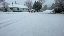
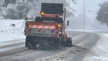
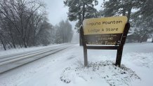
This second storm is much colder than the first and has the potential to dump a substantial amount of snow in the mountains. Snow levels could drop down as low as 3,000 feet by late Thursday into Friday morning and areas as low as Julian, Pine Valley and even stretches of Interstate 8 could see snow.
The NWS issued a winter weather advisory from Thursday morning until Thursday night for the county's mountains. During that time, driving could be slippery on snowy roadways.
"Higher peaks like Mount Laguna and Palomar Mountain could see more than 6 inches of snow," Bledsoe said.
🚧 Flooding
Heavy rain had potential to swell rivers and flood poor-draining areas, which prompted San Diego County to staff up their water rescue team, which consists of six people specifically trained to respond to river floods. The San Diego Fire-Rescue Department also had three swift water rescue teams at the ready.
The storm impacted the Thursday morning commute. Drivers were asked to avoid traveling during the brunt of the storm where possible and to never cross flooded roadways, which could cause motorists to lose control, have car failure and get caught in rapidly rising water, the San Diego County Fire Protection District said.
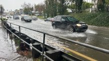
Areas like Mission Valley, Sorrento Valley and parts of the South Bay near San Ysidro are prone to flooding and drivers were urged to stay away and adhere to closures.
In Mission Valley, the San Diego River reached about 9 feet Thursday morning, almost reaching the flooding stage.
Rapid rain could also create mudslides and sinkholes in extreme cases, like a massive one that formed near Syracuse Avenue last year and continued to grow with every rain, according to Jason Nielsen, who lives nearby.
"My house is only about 30 yards from here, and I worry about the hillside just collapsing in and getting worse. I don't see it getting any better, especially as rainy season comes," Nielsen said.
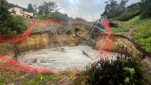
The city of San Diego said the sinkhole was first reported in March 2024 and was caused by deteriorating metal pipes below ground. The pipes needed to be replaced, but recent rain delayed repairs that were to begin this week.
"The walking trail was recently closed due to a sinkhole expanding and construction fencing was re-installed to restrict access," a spokesperson for the city said.
Some unfortunate San Diegans woke up to storm damage on the second day of wet weather around the county.
Perhaps the worst of it took place on the region's roadways, where the California Highway Patrol in San Diego responded to at least 44 crashes as of Thursday morning, snarling the morning commute for thousands of drivers.

🚦 Driving in the rain
The California Highway Patrol recommends that when it's raining, to slow down and keep a safe distance from other cars.
"On a normal sunny San Diego day, we probably respond to about 50 to 75 crashes a day. However, in conditions like this [rain], we normally respond to about 200 to 400 crashes. And a lot of those crashes are those solo vehicle spin-outs. So, it's very important to slow down on the roadways out there," said CHP officer Jim Bettencourt told NBC 7.

The first storm touched down overnight Tuesday, delivering a healthy dose of rain that lasted through Wednesday afternoon. Rain totals were approaching an inch in some places, including San Diego's airport, which had seen its single rainiest day in nearly a year.
In all, from Tuesday through Saturday, San Diego could see between an inch and two inches of rain, Martell said.
There are chances for light showers again on Friday and possibly into early Saturday morning as well. Most of the weekend looks dry and slightly warmer.