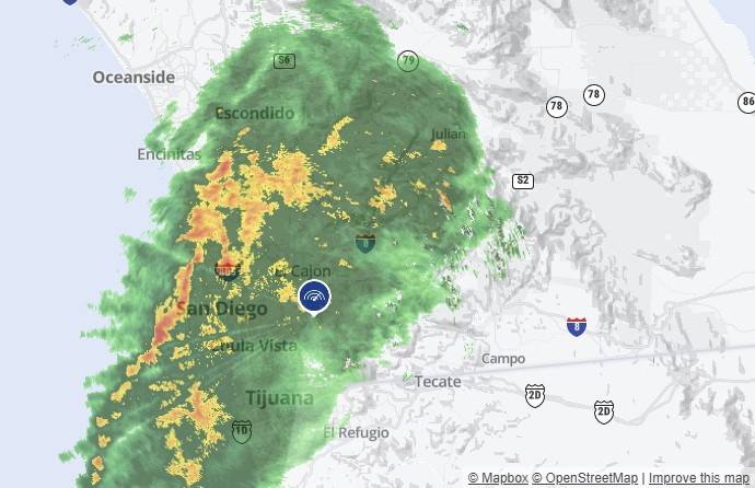
Rain, heavy at times, will continue intermittently across San Diego County Saturday with gusty winds and a slight chance of thunderstorms, according to the National Weather Service.
Record rainfall was reported Friday in parts of San Diego County by the NWS as a powerful winter storm hit the region bringing freezing temperatures, heavy rain and snow and gusty conditions.
At Palomar Mountain, 2.5 inches of rain was reported Thursday, breaking the record for the day of 2.05 inches set in 2015
Get top local stories in San Diego delivered to you every morning. Sign up for NBC San Diego's News Headlines newsletter.
San Diego County Watches, Warnings
- Flood Watch: remains in effect through midnight for San Diego County coastal, valley and mountain areas
- Winter Storm Warning: Until 4 a.m. Sunday in San Diego County Mountains
- Wind Advisory: Until 6 p.m. Sunday for San Diego County deserts.
- Beach Hazard Statement: Thru midnight for our coastal areas.
The City of San Diego closed several river crossings in Mission Valley Friday night in anticipation of the storm.
The National Weather Service says the San Diego River is expected to start rising rapidly at around 6 a.m. Saturday and is expected to reach flood range (above 11 feet 3 inches) from 7 p.m. Saturday to 3 a.m. Sunday. Last year, the river's highest point was 12 feet 7 inches.
NBC 7 Meteorologist Brooke Martell said a cell of heavy precipitation is expected to stagnate over the coast and inland valleys from 6:30 a.m. to about 11:30 a.m. Saturday. For the mountains, rain, wind, and snow will be added to the mix through at least 2 p.m. before there is a slight break in the system. After that, more rain, snow, and wind drive up late Saturday into at least 3 a.m. Sunday for the mountain communities. The same goes for the coast and valleys where the wind will be heavy, at times, from about 3 p.m. Saturday through about 2 a.m. Sunday.

"Anyone that is thinking of traveling – the best thing to do is to stay home and not leave the house – if for some reason someone has to leave your home, the recommendation is to avoid driving through any flooded streets – the saying is turn around, don’t drown," said Marielena Castellanos with the San Diego County Office of Emergency Services.
Utility provider San Diego Gas & Electric has increased the number of field crews and equipment available to restore power as quickly and safely as possible.
As of Friday, top rain totals included 0.97 of an inch in Alpine; 0.85 in Campo and Pine Valley; 0.83 at Lake Wohlford; 0.82 in the Palomar area; 0.79 in Julian and 0.77 at Henshaw Dam, according to the NWS.
Over the period, the bands of dark clouds out of the north dropped 13 inches of snow on Mount Laguna; eight to 10 inches on Palomar Mountain; and about 4 inches in Julian and Warner Springs.
The San Diego County Department of Public Works also warned chains would be needed for travelers in the mountains.
"Please pull over in appropriate locations. Don’t pull over right off the freeway, don’t pull over right off the road, find a nice safe appropriate area. Pullover, enjoy the snow, and don’t cause issues for those who are trying to come up to Sunrise Highway and Highway 79," said Cpt. Israel Pinzon, Cal Fire.
Road Closures Around the County
At 1:30 p.m. Saturday, Caltrans announced the closure of SR-79 at Old Highway 80 in Descanso due to heavy snow and icy road conditions. Eastbound SR-78 at SR-79 in Santa Ysabel is closed except for residents of the area.
The City of San Diego listed the following road closures due to the storm:
- Hancock St. & Whitherby St.
- Pacific Hwy. & Whitherby St.- North and South Bound
- W. Washington St. & Frontage Rd.
- Pacific Hwy. & Noelle St.
- Pacific Hwy. & Wright St.
- Kurtz St. & Estudillo St.
- Kurtz St. & Wright St.
Record-low temperatures were also reported for the day by the National Weather Service.
It was 54 degrees in El Cajon on Thursday, tying the record for the lowest maximum temperature set in 2022. It was 53 in Vista, breaking the record of 54 set in 2022. It was 47 in Alpine, tying the record set in 1962. It was 28 in Palomar Mountain, tying the record set in 2022. It was 33 in Lake Cuyamaca, tying the record set in 1951. It was 43 in Campo, breaking the record of 46 set in 1969.
On Tuesday and Wednesday, when the heavy winds were at their height, the county experienced gusts up to 84 mph in the mountains, 67 mph in the inland valleys, 60 mph in the desert and 56 mph along the coast.


